Point Cabrillo

We walked the path to the lighthouse in the early morning fog. It wasn’t a thick, soupy fog, but a heavy wispy one that resembles a person’s breath on a cold morning. The faint shapes of low hanging clouds could still be seen as we walked the paved path through a field of tall grass and trees.

It was peaceful, being the only ones on the trail.

Well, there was us and a coyote.

I wasn’t exactly expecting to see any, but I happened to look up and saw something dart across the path. It stopped on the other side, practically hidden, the tips of its ears just visible. The coyote peered at us through the tall grass, only for a moment, before trotting away.

We continued along the path, which I think was about a mile long. Birds of all kids flew about while small rabbits hopped along on their way.

And, of course, that’s when we found the sign cautioning people about potential mountain lion sightings in the area. (Coyotes are one thing. I’ve seen them before on multiple occasions, but a mountain lion is an animal I never want to come face to face with. So, needless to say, I was little…scared.) Luckily, we made it to the lighthouse (and back) without seeing a mountain lion.

 Once out of the thick of the field, the trail leads to multiple houses which used to belong to the lighthouse keepers. They’re painted in the same color scheme as the lighthouse itself and the one you are welcome to enter, as it’s a museum. The other houses are available to rent on a nightly basis.

Later in the morning, when we reached the lighthouse, fog still hung overhead. It shrouded the ocean, obscuring the view (even from the edge of the cliff). But this was real weather, not the bright, sunny days we always see in pictures. There was a part of me that wanted the sun, but the clouds and fog were what lighthouse keepers and those at sea had to deal with most of the time. So, to see the lighthouse and the ocean under these conditions was, in a way, something special. It, once again, brought about the reality of the hardships of being a lighthouse keeper and living in such an area.

Point Cabrillo, the place in which Point Cabrillo Lighthouse stands, has a long history – from the Pomo to Spanish explorers to shipwrecks.

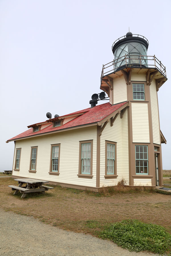
The lighthouse was built in response to the numerous shipwrecks. They began construction in 1908 and a year later, in 1909, Point Cabrillo Light was operational.

But it wasn’t until 1935 when a foghorn was installed. (And based on the fog we saw they probably could have used one sooner.)

The Coast Guard had control of Point Cabrillo Light in 1973, at which point a modern rotating beacon was mounted outside on the roof.

In 1991 Point Cabrillo Light was placed on the National Register of Historic Places.

I love when lighthouses are recognized as historic places. They were built so long ago and are filled with so much history, as is the land they were built on. Lighthouses come from a different time, when people lived a different type of lifestyle. They breed a certain mystery and charm. The fact that any lighthouse is still standing today is a gift.

Today, the history, mystery, and charm or Point Cabrillo Light can be explored. And, when looking up into the light tower, the Fresnel lens still sits proudly in the lantern room.

To see more photos of Point Cabrillo and Mendocino, CA, you can do so by clicking here.

The Path to Point Bonita

From the top of the hill there’s a beautiful view of the bay. Follow it out and you can see the Golden Gate Bridge, Fort Point (shadowed by one of the bridges arches), and San Francisco in the background.

We drove around the city to get to this point, through hills of lush green. It seemed like another place and time. All that marked the signs of civilization were the telephone poles and wires. Otherwise…there was nothing but rolling green hills as far as the eyes could see. The beauty of nature surrounded us and I was surprised something like this existed so close to a bustling, crowed city.

But from the top of the hill, you can see it all – nature extending toward the city – and it was all beautiful in its own way.

Continuing along the current path will lead to Point Bonita, a lighthouse originally constructed in 1855. First, of course, comes the 1 mile walk to get there along with all the sights.

The path weaves through a small patch of trees, always staying parallel to the ocean. At one point there is a small beach where harbor seals come to rest. There’s also a large rock not far from the shore where harbor seals haul themselves up to rest, which, not surprisingly, is called Seal Rock.

On this particular day there were a dozen seals or more on both the beach and the rock. The were a beautiful sight to see, both adorable and wild.

Continuing on from Seal Rock, not too far away, around a bend, is the entrance to the Point Bonita tunnel. (Yes, you must walk through a short tunnel. It can be a bit claustrophobic at times…especially if there are people coming in the opposite direction.) The tunnel was constructed by hand in 1876 and took 4 to 6 months to complete.

Once on the other side of the tunnel, the dirt pathway continues on. It leads you along the rocks with the ocean at your left, across a small bridge and then to the suspension bridge that leads directly to the lighthouse. But, first, back at the tunnel…if you turn around it almost appears like a hidden passage. Carved through the rocky mountain, the exit (or entrance, depending on which way you’re going) has different species of plant life and wildflowers growing all around it. It’s beautiful.

The suspension bridge is the last bit of walking that needs to be done before setting foot on lighthouse ground and seeing Point Bonita up-close. And while the lighthouse was constructed in 1855, it wasn’t built where it stands today. Originally, Point Bonita sat on a cliff much higher (near the place where it sits today), but was moved to its current position in 1877, due to the fog. Now its light was at a level that could be seen by ships. (The tunnel was built a year earlier.) For decades there was a natural path to the lighthouse along the rocks, but, due to erosion and other natural causes, it crumbled. In 1954 a suspension bridge was built to get to and from the rocky cliff where Point Bonita sits. And this is still how people reach the lighthouse today.

When looking at Point Bonita it’s easy to see how beautiful of a lighthouse she was in her prime. Still, even today, despite the bit of rust and chipping paint, she’s beautiful. To have a structure sit so close to the ocean, enduring decades of rough elements, and still have it standing today is amazing. Even the Fresnel lens still sits in Point Bonita’s light tower.

While still remote, Point Bonita was, in many ways, easier to reach than Point Reyes. In both cases it was a trip worth taking. Words can’t fully express or describe the feeling and sights of such beautiful places. I believe it’s something you truly must see for yourself. And no matter how remote, how difficult a place is to get to…it’s the journey along the way as much as the destination that makes such a trip worthwhile.

To see more photos from Point Bonita, you may do so by going here.

The Journey to Point Reyes

Sitting on the edge of a cliff, overlooking the ocean with her dense fog and windy conditions, is the lighthouse known as Point Reyes. On days where the fog lifts or the sun breaks through the clouds, the red roof of the light tower can be seen from the stairs leading to the lighthouse. For there are over 300 steps, down a steep mountain cliff, that must be taken before reaching flat ground and Point Reyes itself.

And that is only the beginning…or the end, when the destination is finally reached.

Point Reyes is one of the most remote lighthouses I’ve visited, to date, and the journey begins long before setting foot on lighthouse grounds.

There’s quite a long drive before even reaching the parking lot. It’s a beautiful and worthwhile drive though. The narrow, one lane road, weaves through hills and valleys populated by wildflowers and cows. Hawks can be seen soaring above, sometimes swooping into the tall grass to catch their prey. Other, smaller birds, flit around or perch themselves in bushes, singing their happy songs.

And from that moment on it seems like a different world.

There are no houses, no people, and rarely any other cars. It’s just you and road, surrounded by cows and nature.

Upon reaching the parking lot, there’s a half mile walk (mostly up hill) before reaching the stairs leading to the lighthouse, but it’s a walk as beautiful as the drive.

A paved pathway leads through the wilderness. Looking out from above you can see a small stretch of beach where the ocean ebbs and flows onto its shore. Lining the beach are tall cliffs, reaching inland and transforming into the hills and valleys you recently drove through. And down all sides of the cliffs are grass and bushes sprouting. The bushes produce yellow flowers which dot and blanket the landscape with color. All types of birds, big and small, fly, perch, or sing. And every now and again a deer or two can be seen among the bushes and wildflowers.

Finally, the stairs appear. Over 300 steps to the lighthouse, carved into the steep mountain cliff and surrounded by plant and animal life with the ocean crashing below.

Then…Point Reyes.

The point at which the lighthouse stands today was chosen in 1855, but construction was delay due to disputes over the price of the land.

On December 1, 1870, the light of Point Reyes was lit for the first time. It was manned by lighthouse keepers until 1975, when it was automated, but the Fresnel lens still sits inside the tower.

In 1991 the lighthouse was placed on the National Register of Historic Places.            

Point Reyes is, by far, one of the most remote and difficult lighthouses I’ve ever visited, but all the walking and climbing is worth it in order to see this beautiful, historic lighthouse. And it’s not simply the lighthouse, but the land and all the nature around it (along with the journey to get there) that makes this a truly memorable experience.

To see more photos from Point Reyes, you may do so by going here.

Point Sur Light Station

It was a foggy, windy day.

No, that would be an understatement.

The fog wrapped itself around the mountain. It hung over the ocean – so thick I could just barely make out the rocks and seals below the cliffs while hardly even seeing a mile out to sea.

And the wind ripped through clothes, no matter how many layers you wore, to chill the bones. It beat against my face until nose and cheeks stung, turning a light hue of red. At times the strong winds threatened to blow me over, unless embraced, at which point I could lean into them and they held me up. It was worse at the top of the short tower, known as Point Sur Lighthouse, where it was a battle to walk in the winds as they reach strengths of a small hurricane.

It wasn’t the beautiful, clear sunny day I’m sure everyone was hoping for, but it seemed to me that these conditions were more realistic. For when living and tending a light on a mountain in one of the most remote places, 270 feet above sea level, I’m willing to bet the fog and wind have a heavy command over the area.

The mountain, or rock formation, on which Point Sur was built came with more struggles than its remoteness. Looking at it today, you can see the top where all the structures are built is flat, but it wasn’t always that way. It used to come to a point. However, in order to build they had to blast the top off to gain flat land. Aside from creating the proper ground to build there was also building issues and difficulties getting the supplies up a “steep 360 foot grade” mountain, supply issues, money issues, the general steepness of the mountain, weather, rough waters, water supply issues, lack of proper roads, and landslides. (These are only several of the struggles encountered at Point Sur, which I encourage you to read about in detail as the problems are as interesting as the solutions.)

Once complete, Point Sur Light Station had a house for the head keeper, a triplex for assistant keepers, a cistern (and later a water tower), a barn, a carpenter and blacksmith shop, an oil house, and, of course, the lighthouse.

Construction on Point Sur began in 1887 and was completed two years later in 1889. The light was officially lit on August 1st of that year.

As I toured the light station, I tried to put myself in the mindset of what it would’ve been like to live there. While beautiful and peaceful, I could only imagine the harshness of the environment and way of life up here on this rock. Even inside some of the buildings, such as the head keeper’s house, their true way of life can never be experienced, only imagined. (And whatever happened at Point Sur, it’s said to be haunted, but that’s a story for another time.)

From its beginning construction in 1887 to the time the last lighthouse keeper left in 1974, Point Sur experienced many changes and advances in technology. The deep history of this place is long and interesting. It involves more than I could ever write in one post. So, I encourage those who are interested to seek out and read more about this remote, yet beautiful light station.

To view more photos from Point Sur Light Station please visit my website.

Piedras Blancas Light Station

It’s strange to see a lighthouse without its top.

But it’s also a unique situation that would leave a lighthouse looking this way.

And that’s exactly the case with the Piedras Blancas Light Station.

Originally standing at 100 feet, the Piedras Blancas Light Station is now reduced to about 70 feet. Over the years it suffered damage from earthquake after earthquake until, in the late 1940s, one final earthquake rendered it structurally unsound. In 1949 the top three levels – fourth floor landing, watch room, and lantern – were removed.

Construction on Piedras Blancas Light Station began in April 1874 and was complete by February the following year. It was illuminated for the first time on February 15, 1875.

A fog signal building was constructed in the early 1900s.

As was the case at numerous lighthouses, if not all lighthouses, the life of a keeper was difficult. Not only did they face adverse weather conditions, but they also struggled with how to obtain a proper supply of food and water. Their lives were one of isolation while their work was labor intensive.

At Piedras Blancas Light Station fishing was a popular pastime and plenty of abalone was collected for food. As for water, keepers collected rainwater from the roof. At other times water had to be purchased and brought by wagon.

Despite the harsh weather, isolation, and difficult lifestyle, Piedras Blancas Light Station is a beautiful place.

Today there is a trail that leads around the perimeter, runs parallel to the coast. Walking the trail is both beautiful and peaceful. There’s plenty of interesting rock formations as well as plant and sea life. Flowers and other plants grow on land while elephant seals, sea lions, sea otters, gray whales, and many other animals have a chance to be spotted.

The fuel building still exists and continues to hold the lingering scent of gasoline.

The fog signal building, originally built in 1906, has been restored.

The entrance gate (1910) and the water tower have had beautiful replicas constructed.

The Piedras Blancas Light Station still has no top. The goal is to one day restore the tower and lighthouse to its former glory. Still, even missing it’s last three levels, it doesn’t take away from this lighthouse, or this place, any of its history or beauty.

Pigeon Point Lighthouse

Perched on a cliff and standing tall against a backdrop of crystal blue skies, Pigeon Point Lighthouse can be seen long before arriving.

Built in 1871, it’s the tallest lighthouse on the West Coast. (At 115’ it ties Point Arena Light.)

The lighthouse has a long, interesting history – beginning with its name. In 1853 a ship by the name of Carrier Pigeon “ran aground,” as they say. Or, in other words, it was shipwrecked. In honor of this ship the lighthouse was given the name of Pigeon Point.

And this point must have been a great hazard to ships out at sea with all its rocks and jutting cliffs, not to mention the rough waters and crashing waves. Near the coast (but still pretty far out at sea) there is a large rock formation called Prisoner’s Rock, as many sailors used to become stranded there.

This spot along the coast also has a history of whaling. Below the lighthouse is a small beach which sits in a cove. It’s called Whaler’s Cove Beach and Whaler’s Cove. A set of (mildly sketchy) stairs lead down to the beach. The further down, the steeper the steps. The further down, the more pungent the aroma of seaweed.

As far as history goes, that’s only the beginning, a small taste of all the decades.

Pigeon Point Lighthouse sits in a picturesque place, as most lighthouse do, but no description can do it justice. It must be visited and experienced. And it is such a wonder how people lived in this beautiful, rugged place out on a cliff, surrounded by the ocean, the rhythmic sound of waves rolling toward the shore and crashing against the rocks, tiny flowers and other plants growing all around, birds soaring through the air and singing their sweet songs, clear blue skies (when there’s no storm in the forecast), the warm sun mixed with the sea breeze, and the smell of the salty sea air.

To see more photos of Pigeon Point Lighthouse and Pescadero, CA please visit my website.

Point Pinos Lighthouse

Point Pinos Lighthouse is situated on a beautiful peninsula in California, surrounded by gorgeous grounds and the ocean.

The lighthouse has a long, rich history dating back to 1855. (Unfortunately, I can’t write about it all here – it would be too long – but its history is worth researching.)

It’s the oldest continuously operating lighthouse on the West Coast and home to the first female lighthouse keeper in 1856. There were actually a few female lighthouse keepers at Point Pinos, the most famous being Mrs. Emily Fish (1893 – 1914). She was known as the “Socialite Keeper” because she loved entertaining her guests at the lighthouse.

Point Pinos Lighthouse is small, but beautiful, it’s red cap housing the light. The surrounding landscape and garden offer tranquility. The animals – deer, Monarch butterflies, birds, etc. – can usually be found in abundance.

Wandering the grounds and walking into this old lighthouse feels a little like stepping back in time. The feeling of beauty, tranquility, and history is not one that can be done justice with words. It’s something that must be experienced.

To see more photos of Point Pinos Lighthouse and California please visit my website.

On Top of the World

It’s 199 steps to the top.

It’s always been 199 steps to the top.

But, somehow, it felt easier this time around.

Maybe it was because I had done it before or because it wasn’t a steamy 90 degree day.

Whatever the reason, after 199 steps, I made it to the top of the world.

At least that’s how it feels when you’re standing at the top of a lighthouse. (And I know there are taller lighthouses. For instance, the Absecon is 216 steps and there are others that have even more, but standing at the top of any lighthouse gives the feeling of being on top of the world.)

So, we climbed the Cape May Lighthouse one step at a time. The cast iron spiral staircase wound its way up through the interior of the lighthouse. Every so often there was a landing with a window or, the further up we went, a porthole. Each looked out at the world from a different height, changing the perspective of the viewer. As the distance between where we were and the top diminished, the steps narrowed. At the top there was a door that led outside or, as I like to think of it, the top of the world.

Stepping through the door and out onto the balcony two things happened: 1.) a strong wind immediately hits you and 2.) you’re struck by the gorgeous view while also realizing just how high up you are at that moment in time.

All around the lighthouse a strong wind hits from every angle. It’s probably partially because of how high up you are, but also the wind blowing inland from the ocean. It wasn’t a cold wind, but it was cold enough to send goosebumps up and down my legs. Still, there was a part of me (okay, let’s be honest, all of me) that didn’t want to leave. I didn’t want to make the trip back down. To this day I’m still not sure if it was the fact that I was with my special someone, or the peace I felt, or the view. Or, maybe, it was a combination of all three.

And that brings me to the view, the gorgeous view. You can see the parking lot, the town, the beach, the old WWII bunker, the ocean, and all the people (who resemble the size of ants) walking around below. I imagine this is how birds must feel when they fly. But it’s also one of those moments when you realize how small you are in the grand scheme of the world. Looking out at all that is around – all the places, all the people, all the beauty – it serves as a reminder just how big and beautiful the world is while we are simply one small part of it.

But in this place that feels like being on top of the world, of imagining this is how birds must feel, of lifting your own metaphorical winds and letting the wind take you higher and higher until you’re soaring over the ocean waves, of realizing we’re all just one small part of a bigger story, there’s also one simple fact that doesn’t need to be so philosophical. And that fact is the undeniable beauty which surrounds us.

Ocean City, NJ – Day Two

It was a complete turnaround from the previous day. The gray skies that had brought rain were now burning off, letting the sun shine. It’s warm rays were gracing the earth and the temperature was rising. There was still a wind blowing inland, but by now it was more of a breeze over calmer waters.

Today was the perfect day to do some exploring. Today, I was headed down the coast to Cape May. There were many things I wanted to see — the Cape May Lighthouse, the WWII bunker, the S.S. Atlantus, Sunset Beach, the WWII Lookout Tower — and the list goes on.

The first place I stopped was the nature preserve. I wanted to walk the paths with my camera and see what kind of wildlife would enjoy making an appearance for a photo opportunity. Unfortunately, most of the birds, reptiles and other animals seemed to be camera shy. I only saw one turtle (who happened to be making his way across the hot asphalt of the parking lot and decided to rest in the shade produced by a car’s back bumper), several swans (who appeared elegant) and many other birds (of names I’m unsure of). I did, however, still enjoy the beauty of nature and the Cape May Lighthouse could be seen from different angles while on the paths.

WWII BunkerNext up was the remains of a WWII bunker, know as Battery 223, built in the 1940s. There was a straight path from the nature preserve to the beach where it sits. Upon seeing it, I thought about how big and strong it looked, but knew that it had changed drastically over time. I’ve seen photos of this bunker throughout the years and the changes are astounding. People used to be able to walk under it, but due to land transformation that’s become impossible. It used to sit on top of giant, strong pillars (and still might, although it’s hard to say for certain) and the ocean would rush up and surround it. Now the pillars can’t be seen and the bunker appears as if it’s sitting on top of sand. I believe there was also a time when people were able to climb a set of wooden steps, which were built after the war sometime in the 70s, to an observation deck and even walk inside. I have no proof or photos of these steps or an observation deck, only word of mouth from those who say they remember it from years ago. As for the inside, I’ve seen only a few photos and as amazing as it looks it’s unfortunately covered with graffiti. There’s a large part of me that wishes I could’ve seen the inside for myself, walk the halls and enter the rooms that so many brave souls did long ago, but today the entire structure is sealed off. People can still walk around the perimeter of the bunker and touch the concrete walls, which I did, gladly. I had a feeling of awe as my hands rubbed along the concrete. When it comes to old, historical places part of me can’t believe I’m actually seeing it while the other part can’t believe it’s still standing. And the whole time I’m playing its history in my head, as if I can see it for what it was back in its prime as well as what it is today — a wonderful piece of history.

The Cape May Lighthouse was next on my list of places to go. It was built in 1859, the Cape May Lighthouse (Black and White)
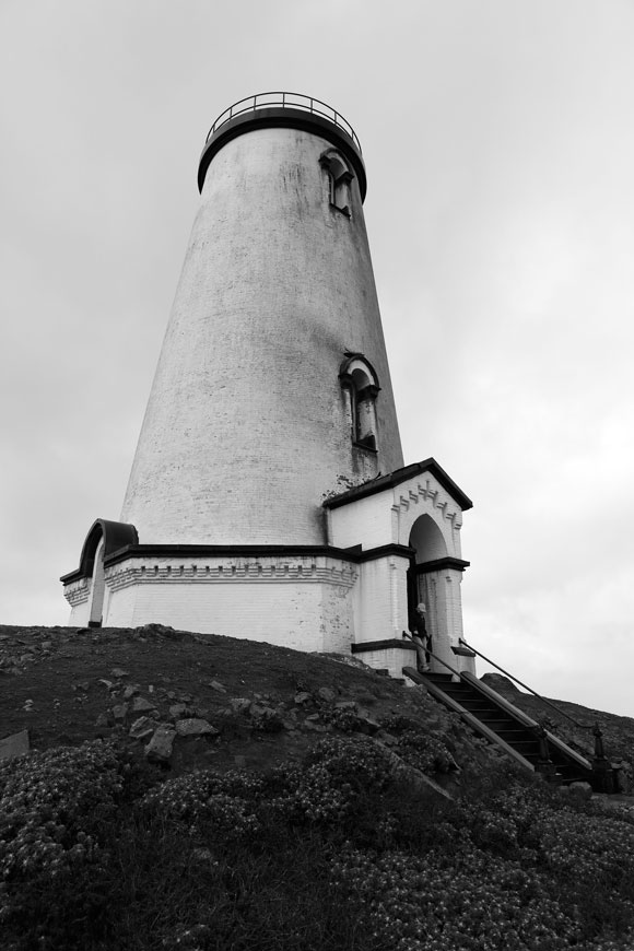
same year it was first lit. In 1946 it was automated and is still operational today. As is the case with many lighthouses today, people are able to climb the stairs, like lighthouse keepers. There were 199 steps to the top of the lighthouse and I climbed every single one. My journey started at the bottom and continued in intervals, as I stopped briefly at each landing to observe the view. At the top, surrounded by bright red metal bars, what I saw was breathtaking. From one side I could see the entire beach, another side the town and from another side I thought I could see the remains of a sunken ship sticking out of the water.

SS Atlantus (Black and White)The S.S. Atlantus was launched in 1918, a month after WWI ended, but was used to bring American troops home from Europe as well as transport coal in New England. In 1920 the ship was retired and six years later (1926) the S.S. Atlantus was purchased. The plan was to use it as a ferry dock in Cape May, NJ along with two other concrete ships. So it was towed to Cape May where it was kept waiting, but when a storm hit the ship broke free and ran aground 150 feet off the coast. Any attempt to free the ship was unsuccessful. By the late 50s the S.S. Atlantus begun to break apart in its midsection. I’ve seen photos of the ship through the years, as it’s slowly broken apart and it’s striking how large it used to be verses what remains of it today. From what I can tell there’s barely anything left. Still, there’s something about seeing it in person. Maybe it’s the sight itself. Maybe it’s the history behind the ship. Maybe it’s a little of both. Whatever the reason, the S.S. Atlantus is still an amazing sight to see with a great history. Colored Stones and The Ocean

Since the remains of the S.S. Atlantus sits off the coast of Sunset Beach it was easy to see both (practically simultaneously.) While the beach is sandy there are more and more colorful rocks and pebbles closer to the water. The way the sun bounces off their surfaces makes them sparkle and shine. It was a beautiful sight to behold.

WWII Lookout Tower (Fire Control Tower No. 23)The WWII Lookout Tower (Fire Control Tower No. 23) was near Sunset Beach so it was my next, and last, stop of the day. Built in 1942 it was one of fifteen towers meant to aim batteries of coastal artillery from North Wildwood, NJ to Bethany Beach, DE. There used to be four of these towers in Cape May, but two were torn down while the other two still stand. However, the one I visited is said to be the last remaining restorable WWII tower in New Jersey. Behind the tower is a deck with an “All Veterans Memorial” and inside the tower, on the third floor, is a “Wall of Honor” which features photographs from over 100 area WWII veterans. Although, I didn’t see this wall for myself. Considering this was my last stop of the day and all the other walking and climbing I participated in, I asked my legs a very serious question — if they thought they could make it up the nearly 200 steps. Reluctantly they responded with a no. It was the day’s first disappointment for me, but definitely on my list of things to do on my next trip to Cape May.

I loved the history of Cape May along with its beauty. If you’re ever in the area and enjoy history I’d recommend checking these place out, or go for the simple beauty of the ocean.

To see more pictures please visit my website.